 LOTS of interesting stuff happens when you go walking without a map in a strange country. You see things you didn???t expect to see. Conversely, you don???t see the things you expect to see because you can???t work out how to get to them . . .
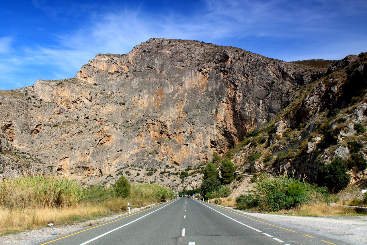
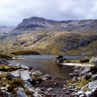
Between my new home-town of Orgiva and the Mediterranean coast, the Rio Guadalfeo flows through a spectacular gorge in a range of limestone hills known as the Sierra de Escalate. I???ve driven through the gorge on the old Granada road many times, and cycled through it one hot day in July. But I have not, as yet, followed the paths in the river valley or picked my way along the karst cliff-tops many hundreds of metres above. And that???s what today???s walk is about.
Karst is a great word with a suitably crunchy and crumbly sound. It denotes an area of soluble rock ??? usually limestone ??? where the passage of water over millions of years has altered the landscape and formed vast underground drainage systems.
The term originates in the Karst plateau, which lies largely in Slovenia though extends into northern Italy. Classic examples of karst landscape can be found in the Pennines, north-east Cumbria, the Mendips and in the west of Ireland. Here in the Sierra de Escalate, in southern Andalucia, the karst landscape is among the world???s finest.
I leave the van beneath a motorway bridge near the town of V??lez de Benaudalla and strike out along a track I spied a few weeks ago, expecting it to deliver me to the airy cliff-top ridge above the gorge. It doesn???t.
But I discover ??? almost hidden from view in a thicket of pine ??? a deep, stone-built pit that has been used for the storage of burnt or crushed lime. It is the second ancient lime pit I???ve found in these parts. This one has a narrow doorway nearly four metres high. I think that???s interesting. I???m sure you do too.


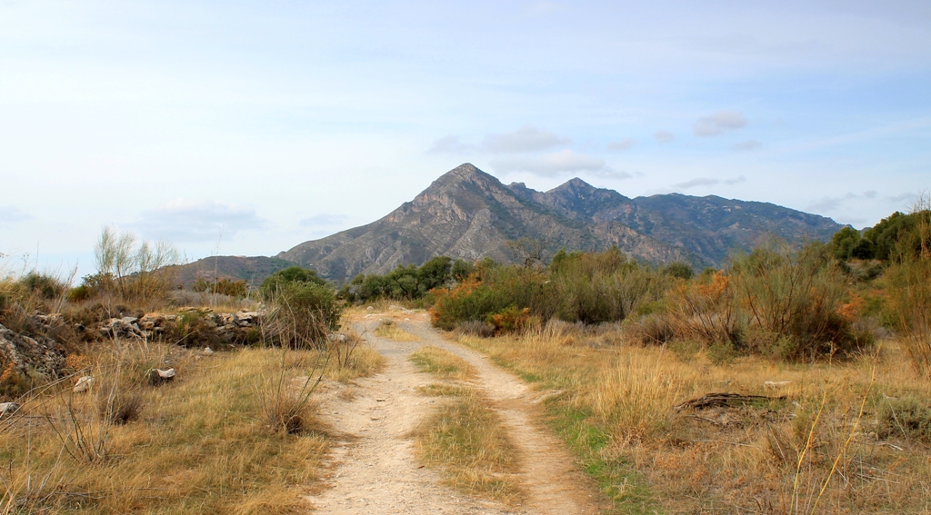
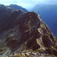
 I return to my starting point and set out along a different track. This doesn???t deliver me to the top of the gorge, either. But there are fine views of the neighbouring mountain range, the Sierra de Chaparral.
 I return to the van a second time and resolve to resume the search for some proper maps when the opportunity arises. Being British, and therefore accustomed to buying first-rate Ordnance Survey maps in a country that has been scrutinised by cartographers more diligently than any other, it comes as a shock to discover that other nations ??? Spain in particular ??? do not put the same emphasis on the practice of self-examination.
With an Ordnance Survey map you can find your nearest town hall, public convenience and cattle grid. But if I wanted to know whether V??lez de Benaudalla had a place of worship ???with tower???, ???with spire, minaret or dome???, or ???without such additions???, I???d be buggered.
I decide to abandon the cliff-top walk and concentrate instead on the route through the gorge. So I drive down to the river, leave the van at the entrance to the first likely track, and immediately blunder into a field full of men picking beans. Wrong track again. So I do that very English thing and take pictures of the bean-pickers, implying I had meant to march into their field and not simply taken a wrong turning.
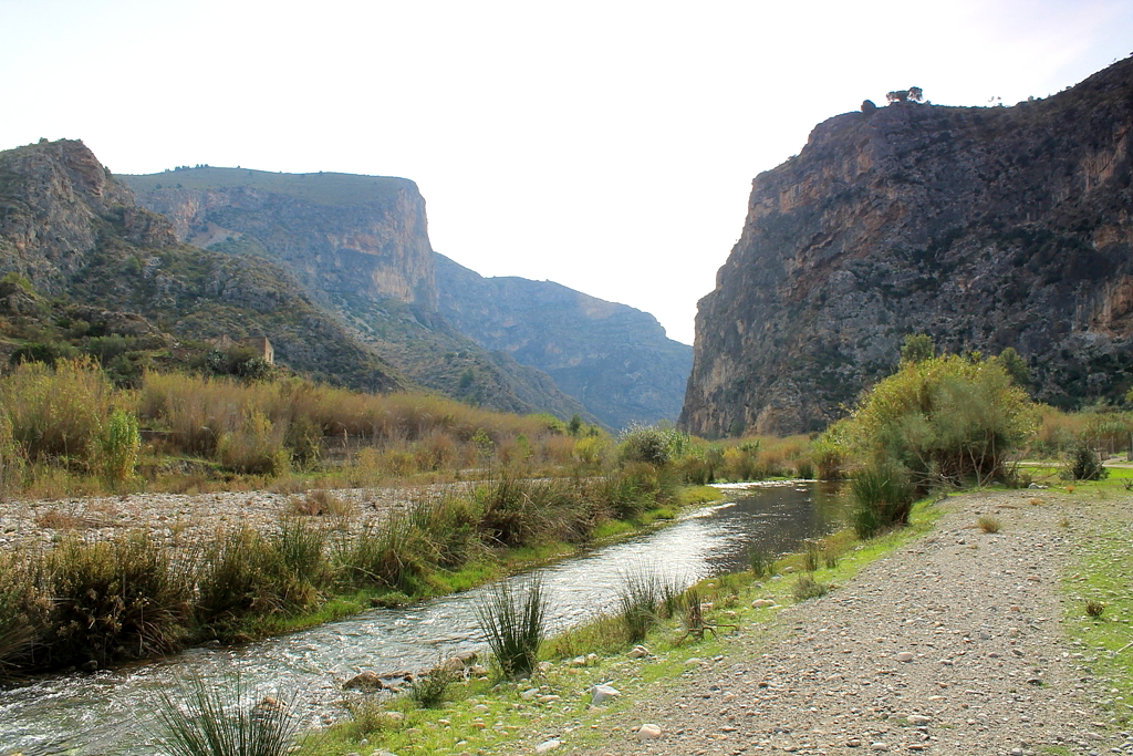
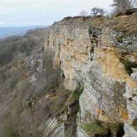
 There???s only one more track heading down the river. Hobson???s choice, but it turns out to be the track I require. It leads me through pleasant plantations of strange fruits and beneath vertical cliffs of honey-coloured stone.

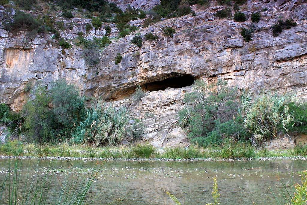
The base of the cliff, showing the end of a phreatic tube ??? in the centre of the picture ??? emerging from a bedding plane in the limestone. Phreatic tubes are caves that formed deep beneath the water table, the water dissolving their sides and roof equally, hence their circular or oval cross-section. Fascinating, eh?


 After a couple of kilometres the track peters out as the gorge narrows, and I am obliged to force my way through thickets of bamboo and splash across the Rio Guadalfeo on no fewer than five occasions. This is the first time I???ve experienced wet socks while walking in Spain. It???s a pleasant feeling in a warm climate.

This section was hard work. I had to remove my rucksack and drag it behind me to squeeze through here
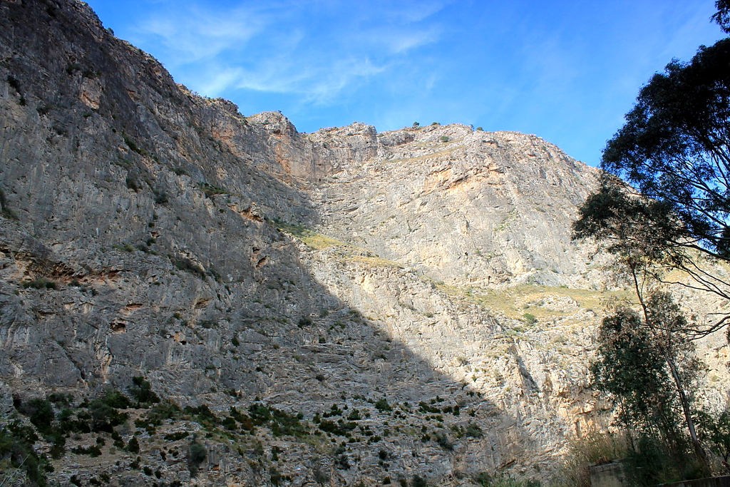
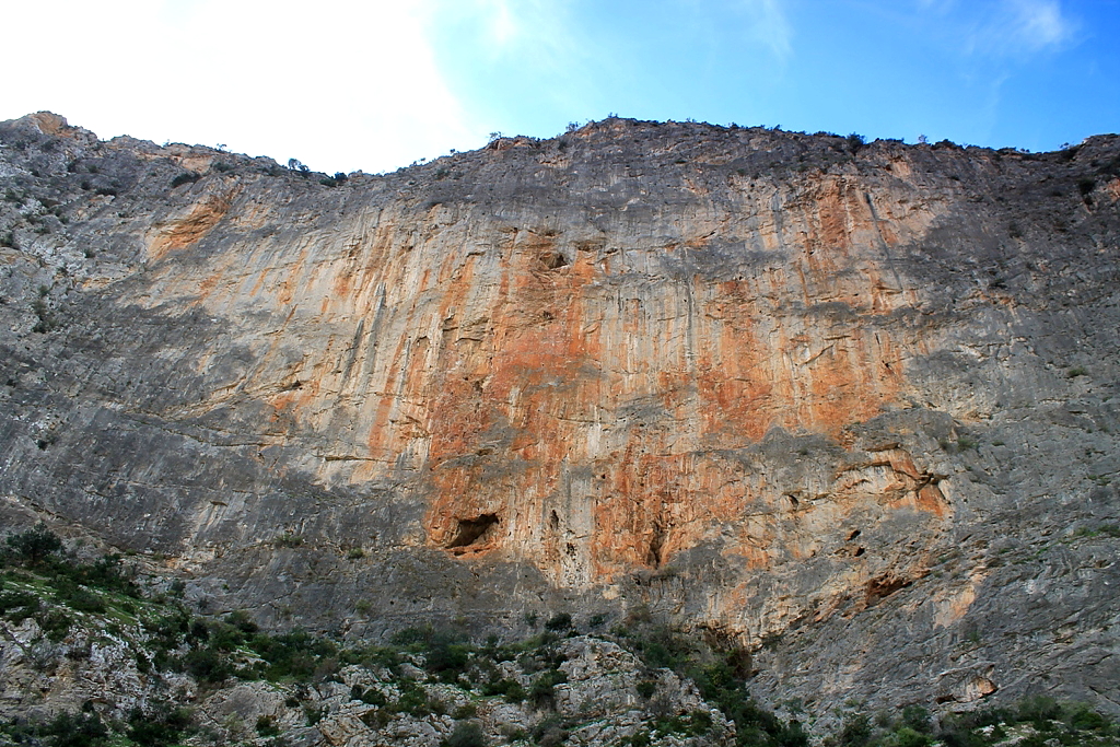
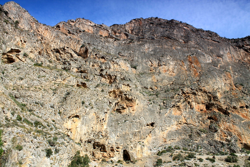
The gorge, which is known as the Gorge of Escalate, Dragon Gorge, or Tajo de los Vados, slices through the karst landscape for several kilometres. The cliffs soar approximately 400m (1,300ft) ??? and almost vertically ??? at their highest point. Take a look at these pictures because my words can???t do justice to the scenery.


 After reaching the gorge???s southern mouth, I turn about and walk halfway back along the main 902 road before fording the Guadalfeo a sixth time to regain the track through the plantations. Job done. Now I???m off home to seek out some half-decent maps on the internet.


A fabulous away-day Alen and well recorded. It looks like there is plenty to explore – get lost in – in the Sierra Nevada/Las Alpujarras, I must return soon.
Saludos,
Alan
LikeLike
Hi Alan. Yes, there is something new around every corner. Plenty to keep me occupied for a few years.
It was you who sent me a link to the picture of the big wheel at Green Hurth a couple of years ago. Thanks for that. Don’t suppose you have any old pictures of the mines around here?
Cheers, Alen
LikeLike
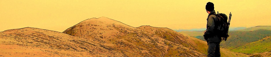
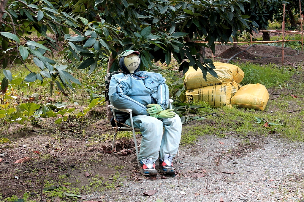
Superb post Alen…what amazing countryside too – I wouldn’t want to wander around a strange country nowadays without a good map, I may have done once (and did, now I think about it) many years ago when I was younger and indestructible – but now I am softer and wouldn’t be comfortable. It just looks like a jaw dropping place to be, with plenty to explore and savour. I love the guy in the chair ????
LikeLike
Hi James. I wish I was young and indestructible again ??? but I suppose we all do.
Yes, the guy in the chair gave me a bit of a start. It’s a nice place to sit and watch the world go by.
Cheers, Alen
LikeLiked by 1 person
What a great landscape and now I understand why you had that cerveza afterwards ????
LikeLiked by 1 person
I’ve had a few more since as well, Cuz.
Alen
LikeLiked by 1 person
Good man!
LikeLiked by 1 person
What’s the big green strawberry underneath the green bananas?
It all makes Gordale Scar and Malham Cove look a bit modest, but then I suppose that’s the English way too: modest gorges. You’ll have to do an expedition concentrating on the caves. They all look promising.
LikeLiked by 1 person
I don’t know what the big green strawberry thing is. I was hoping someone was going to tell me.
Something I haven’t seen in this karst area is limestone pavement, so perhaps the Pennines and parts of Cumbria shine through in different ways. Mind you, it’s warmer here and the beer’s cheaper.
As for caving, I haven’t done any of that in a serious way for nearly thirty years, so I’ll give it a miss, thank you.
Something else they have in the gorge, which I’ve discovered subsequent to the walk, is via ferrata ??? fixed iron ladders zooming up vertical faces for 250 metres. I’ll give that a miss too.
Cheers, Alen
LikeLiked by 1 person
No one will ever get me onto a via ferrata either. The one at Honister looks terrifying.
LikeLiked by 1 person
I’ve been up the old inclines at Honister back in the 1980s before the via ferrata was built. Started at the bottom and emerged on the top of the crag. It was spectacular enough before the via ferrata, so what it’s like now, God knows.
LikeLiked by 1 person
Right. I have received an email from a lady called Alison who reckons the knobbly fruit is a custard apple, also known as a cherimoya. I’ll go along with that because I’ve heard that custard apples are grown in these parts but I’ve never seen one. According to Mark Twain, they are the most delicious fruit known to man. So there you go.
https://en.wikipedia.org/wiki/Cherimoya
LikeLiked by 1 person
Amazing.
LikeLiked by 1 person
This is great exploring, Alen. I enjoyed the read and pictures immensely.
I send you a card link. My hope is that you will have a Morton’s fork instead of Hobson’s choice ????
The link offers Outdoor, Topo…: http://es-es.topographic-map.com/places/R%C3%ADo-Guadalfeo-246630/
LikeLiked by 1 person
I found this site which you already know with downloadable map from the Instituto Geogr??fico Nacional de Espa??a, and is free for personal use.s: http://www.treksierranevada.com/info-maps
Then it’s all up to you ????
LikeLike
I’ve tried the link and I just get an error message, Hanna. And when I locate the site on Google and click on it I get the same message. Perhaps the site is down at the moment. I’ll try again later.
Thank you, Alen
LikeLike
It worked when I tried. The card number is 1042.
LikeLike
Thank you, Hanna. I have learnt something here. I hadn’t heard of Morton’s fork before. Very interesting.
And thanks for the map. I spent an hour last night searching for a little place called La Guindalera, without success. But I found it within two minutes of opening your map.
Gracias, Don Alen
LikeLiked by 1 person
You are most welcome, Your Highness ????
LikeLiked by 1 person
Thank you. It amuses me that whenever you sign a legal document in Spain, such as for power of attorney or the contract when buying a house, your name is always preceded in the text by “Don”, or “Donna” if you happen to be a woman. Therefore I always get recorded as Don Alen McFadzean.
I feel I really should be wearing a fancy waistcoat and big black hat, and riding around on a big black horse. One day, perhaps, amiga.
LikeLiked by 1 person
If you add a picture of Zorro in your next chapter exploring gorges and caves then we will know it’s you ????
It’s interesting to get an insight into the Spanish salutations, Don Alen McFadzean.
LikeLiked by 1 person
Fantastic photos Alen. All that superb rock has me hankering for another winter rock climbing trip to Spain. Busy looking up the area in my guide books.
Mapless exploring is certainly rewarding as you have just proved. Most of my maps are out of date anyhow.
LikeLiked by 1 person
Hi John. I believe it’s also a good caving area, though I haven’t looked into this at all. Also, there’s at least one via ferrata that goes right up one of the highest faces. Not my cup of tea because I can’t deal with the exposure, but interesting all the same.
Cheers, Alen
LikeLike
I was thinking how unsuitable for climbing that rock looked and then the next photo was of a climber on it! Well above my grade. Looks sharp too.
I love a good explore and spent a lot of time when I was on my own in Jordan exploring the wadis (dry gorges) and loved it. Of course, they don’t really have anything in the way of maps there…
Carol.
LikeLiked by 1 person
Hi Carol. I came across four groups of climbers in the gorge, so the rock must be pretty good. It’s way above my standard, too. Easy routes on Wallowbarrow Crag is my limit.
Maps exist here but they don’t sell them in the shops. From what I can gather, the best ones are based on old military maps and you have to order them from various institutions. I really should get myself organised.
Cheers, Alen
LikeLike
With all the exploring you do, you could offer to map some of the out of the way areas for them ???? I used to do pretty accurate maps of our local wood
LikeLike
I was thinking of drawing my own maps for the blog. Might have a go for the next walk.
LikeLike
I like to always know exactly where I’m going these days, but when I was much younger I used to wander around mapless in the local countryside, seeing what I came across and where I ended up – albeit in a much tamer area than where you are! Made me remember how much fun I used to have.
Wonderful photos of the scenery in your new land, too.
LikeLike
Hi Chrissie. Sometimes maps can make a situation worse. I managed to lose myself once above the southern shores of Loch Garry because a huge area of new forest wasn’t shown on my (admittedly out of date) map. A similar thing happened in Glen Carron when I walked the Cape Wrath Trail. But I suppose if I’d bought new maps, these incidents could have been avoided.
I like the idea of wandering mapless. It’s one way to get to know the area. But it does have its problems.
Cheeers, Alen
LikeLike
Hi, Alen. I think it’s saddening to see so many of the old ways falling into disuse: carrying a map but failing to consult it being one example. This was a technique which I employed myself on occasions; although not latterly, as I have become timid and soft with age.
Times were when I would regularly become slightly ‘misplaced’ by virtue of neglecting to refer to the map. This would then be followed by a period of denial, during which it was still considered unnecessary to refer to the map, on the basis that it was only a matter of time before I recognised some prominent landmark. Phase three involved accepting that I didn???t have a clue where I currently was, but my own inner compass would somehow prevail over the unfamiliar terrain.
There was one final part to the process: it involved a pathetic figure, nervously unfolding a OS Explorer or Landranger, praying to the god of the hills that he hadn???t actually walked off the edge of its coverage.
I don’t think it ever found its way into any of the mainstream hill skills manuals.
LikeLiked by 1 person
Hi Dave. Your experiences sound so familiar. I could add to that times (one in particular in the mist on An Teallach) where I was so sure my inner compass was correct that when I did finally consult the map I promptly ignored it and carried on my original course, descending on completely the wrong side of the mountain.
These days I have reached the point where I consult Bing Maps and Google Earth before I set out anywhere. Makes you wonder how Christopher Columbus and Marco Polo managed. Perhaps there were hundreds more budding explorers who set out with huge expectations but just never came back because they got lost.
Cheers, Alen
LikeLike